Thursday, December 4, 2014

[RACE REPORT] Walt Disney World Marathon Weekend, Pt.IV: Course Preview (w. Virtual Run)

Home Race Schedules & Reports > 2015 Walt Disney World Marathon Weekend, Pt.IV: Course Preview with Virtual Run
Home Course Previews Database > Walt Disney World Half-Marathon (2015)

This is part four of my six-part series on the 2015 Walt Disney World Marathon Weekend. Part four covers the course preview, including Virtual Run feature.
Part 1 (Introduction) can be found HERE.
Part 2 (History of the Race & Registration Process) can be found HERE.
Part 3 (Training & Planning) can be found HERE.
Part 5 (Travel, Event Expo, & Pre-Race) will be posted on Race Weekend.
Part 6 (Race Day & Post-Race) will be posted after Race Weekend.

The event's official website can be found HERE.

By now, training should be in full swing for all participants in the half-marathon and greater. Part of training, though, is knowing the course, and tailoring your training to meet the demands of the route (namely, elevation profile). Luckily, for those with limited outdoor training access (it is winter-ish, after all), this course is pancake-flat. So treadmill training should be relatively adequate.

OF IMPORTANT NOTE, however...treadmills are softer, and require less effort. A weekly long-ish run outdoors is HIGHLY recommended so that your joints and bones are also trained for the blacktop-and-concrete race route. Additionally, on treadmill runs, increase the incline to about 0.5%, which should require enough extra effort to mimic the demands of race day.

With that, let's take a look at the race route, with Virtual Run photos (courtesy of Google Earth Street View; most of the interior shots of the Walt Disney World parks are not on Street View, and are photos I took myself, unless otherwise noted).

Course Preview
The Google Maps route can be found HERE.

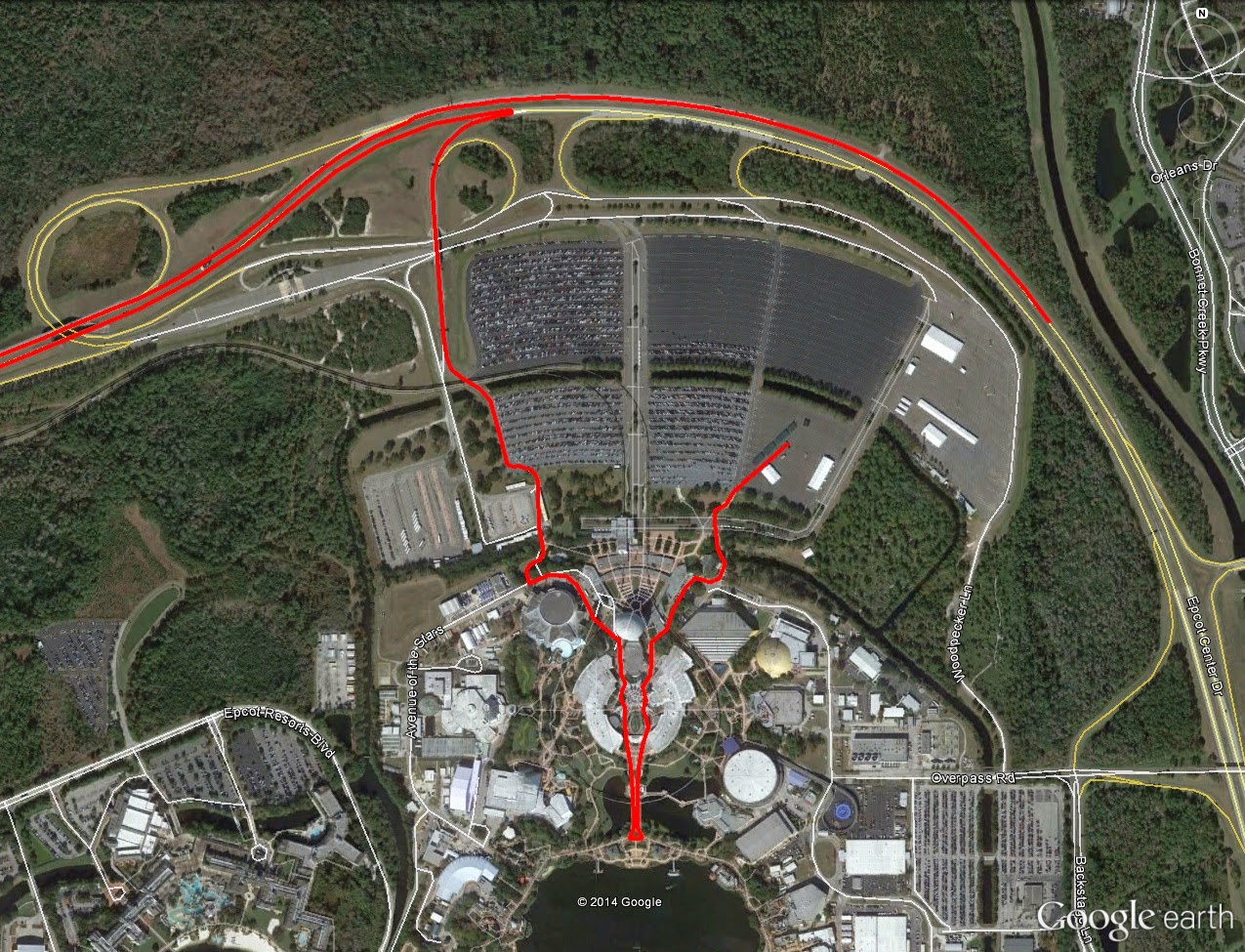
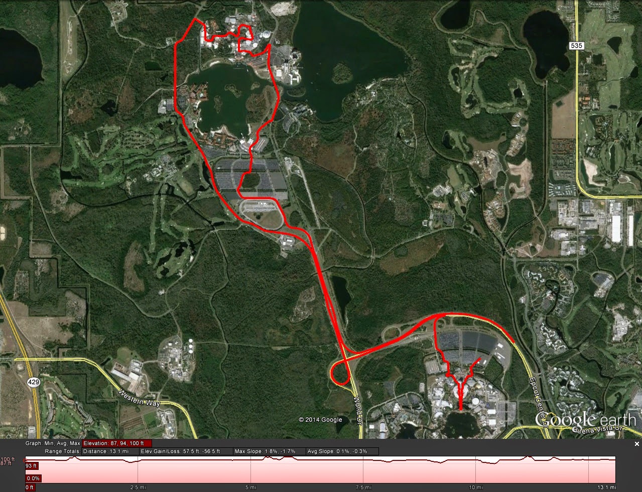
The Google Earth view of the Course.
          Intro
For this course preview specifically, the half-marathon distance will be covered. Maps for the full marathon course, and 5k/10k course can be found using the links right here, or at the marathon weekend's official website, which is linked at the top of the page. Official half-marathon map can be found HERE, or at the marathon weekend's official website.

          Course Basics/Metrics
Here are the basics for the 2014 half-marathon route...
  • Distance: 13.18mi
  • Route Type: Loop
  • Terrain Type: Park Streets, Highway (Blacktop, Concrete)
  • Start Location: Epcot Center Drive, just off the Northeast corner of Epcot's parking lot.
  • Finish Location: Southeast lot of Epcot Center.
  • Start Elevation: 93ft
  • # Major Climbs: 0
  • Tot. Elevation Gain: 56ft (est.)
          Climbs
Not a single damned one. Although, climbing up the freeway exits provides a notable incline each time, but they aren't quite open for analysis via Google Earth. And speaking of Google Earth, the elevation shows as completely flat, which is not quite the case -- this is why I gave both a Google Earth (above) and TrainingPeaks (below) screenshots of the maps.

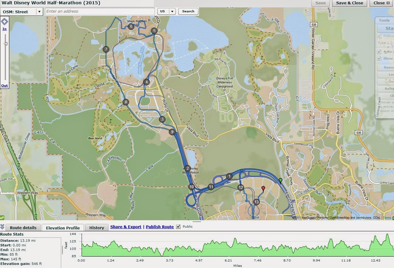
TrainingPeaks gives a little bit more a detailed look in to the very mild undulations that make up the course
(albeit still likely inaccurate, mind you).

          Virtual Run
Start Line through 2.5mi: The half-marathon and full marathon routes start in the same place, along Epcot Center Drive, just Northeast of Epcot's parking lots.

Mile Zero: Approximately where the start line would be. Epcot's parking lots are just beyond the tree line to the left.
The first several miles are wide open: no real elevation change, and very little as far as visual stimulation goes. Simply enough, you're just running on highway.

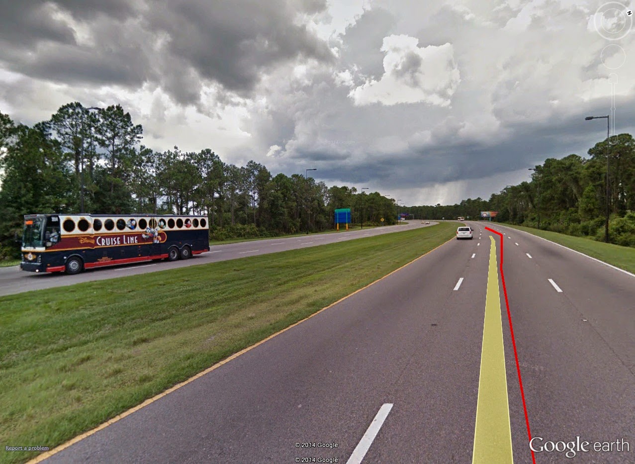
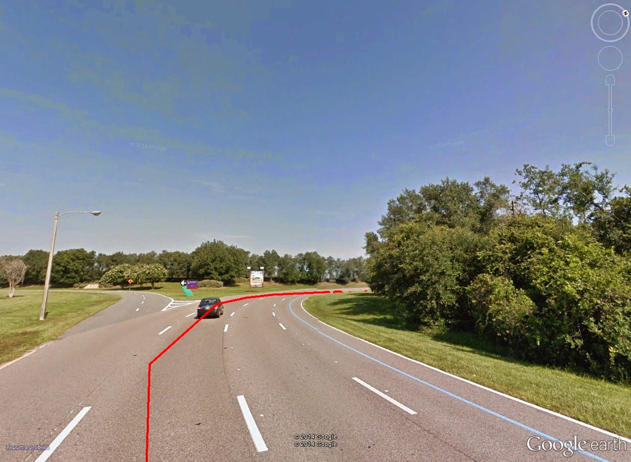
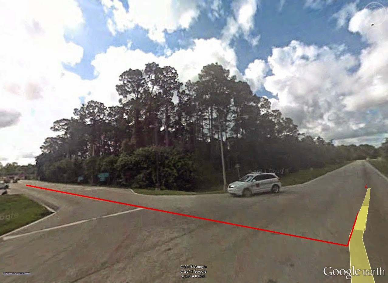
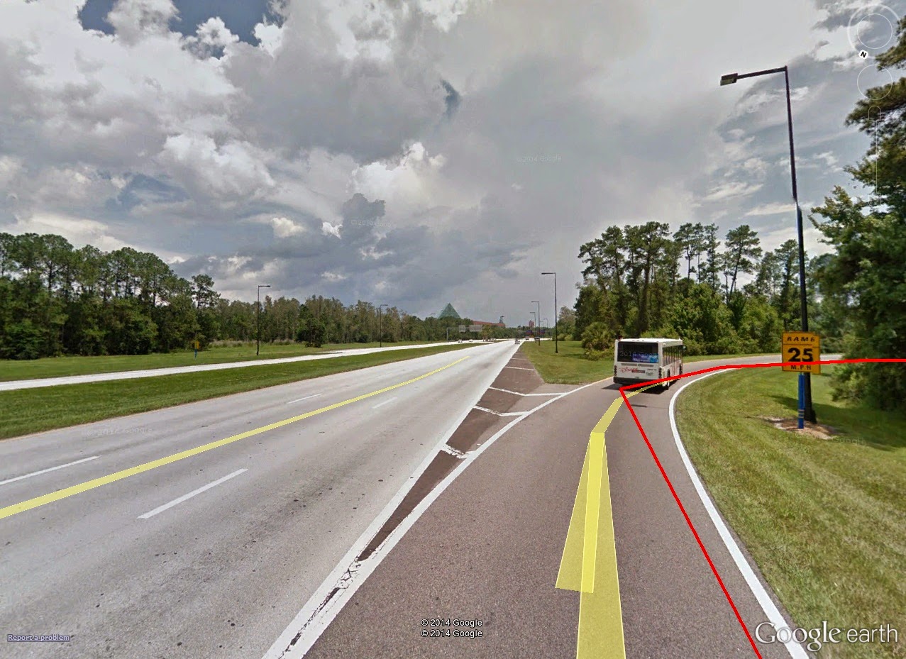
Just short of mile marker 1, you see really the only "incline" of the day: a run up a highway exit, transferring from Epcot Center Drive West-bound, to World Drive North-bound.

0.9mi: Stay to the left on this exit, and it will swing you North on to World Drive towards the Magic Kingdom.
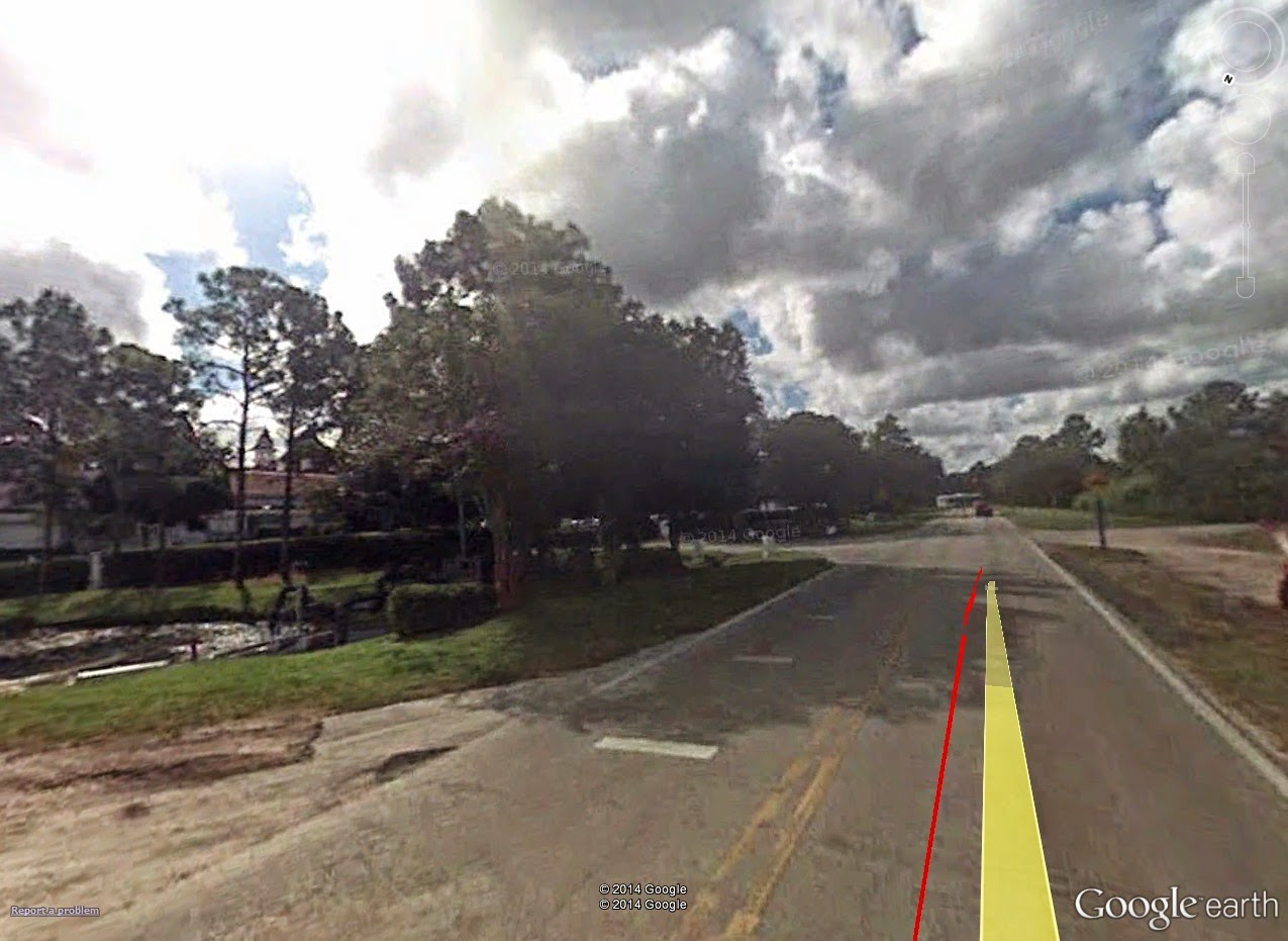
1.3mi: This is about the extent of the course's "hills." Things do get quite narrow on this exit, however.
North on World Drive looks very much the same as Epcot Center Drive, save for the occasional Disney World attraction billboard.

2.0mi: One of the many attraction billboards that adorn the trek along World Drive North.
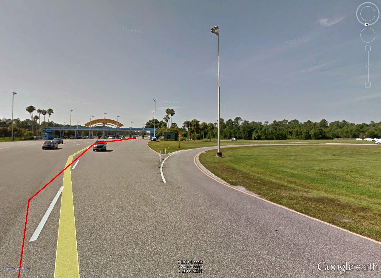
2.5-3.5mi: It isn't until roughly 2 1/2 miles in that things start happening. At just past mile 2.5, you come to the parking lot entrance for the Magic Kingdom.

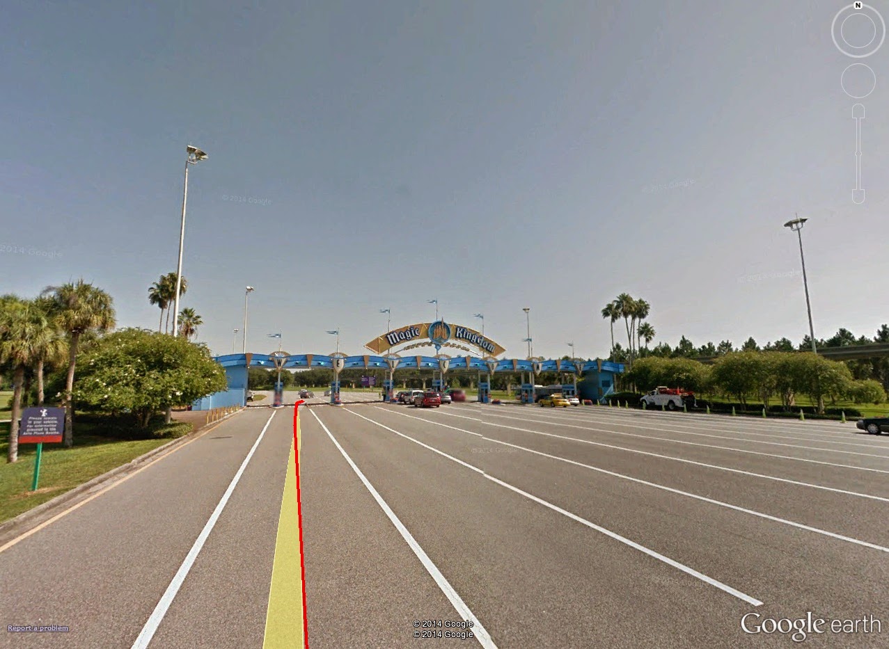
2.6mi: The entrance to the Magic Kingdom, although really it's just the entrance to the parking lot.
Passing by the Richard Petty Driving Experience, runners will keep to the right, eventually cutting across the Southwestern-most corner of the parking lot. Even this run-in, from the parking pass booths to the actual parking lot, is...well...long.

2.85mi: Just short of the 3-mile marker, keep to the right to head in towards the parking lots.
3.35mi: Another half-mile later, you finally get to the actual entrance in to the parking lots. Sheesh.
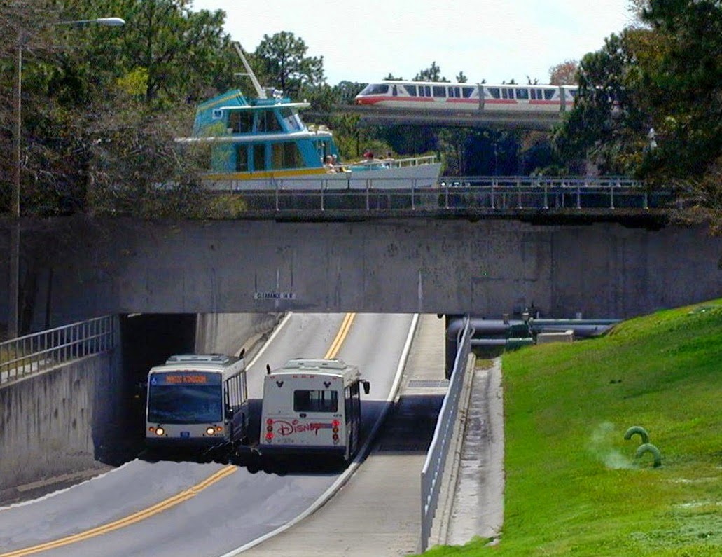
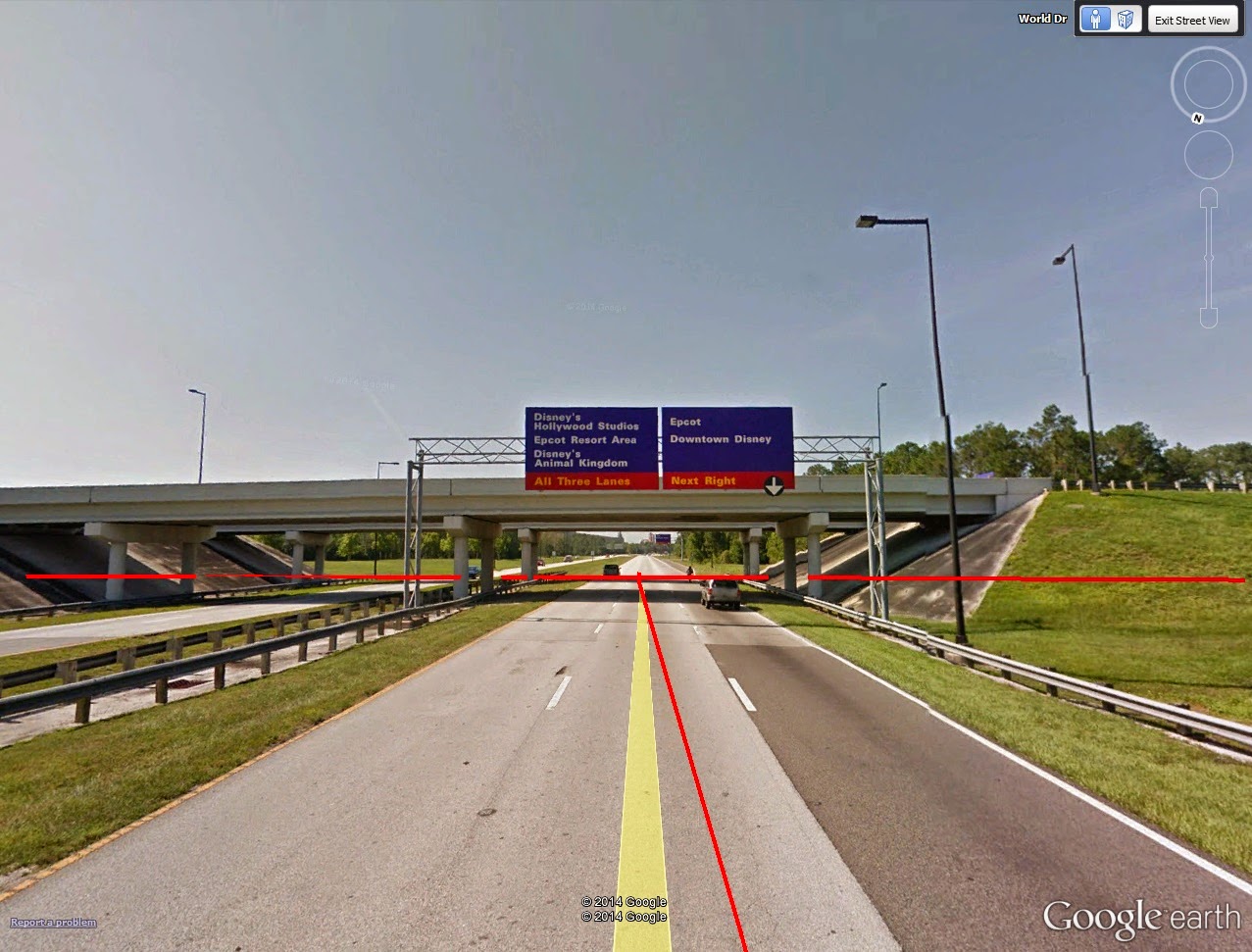
3.5-5.0mi: Past 3.5 miles, at the North end of the lots -- closest to the ticketing counter -- you run under the bridge that normally is reserved for the parking lot trams. Beyond this bridge, you finally come to the ticketing booths and entrance in to the monorail stations -- but you're not at the actual park yet!

3.85mi: Nearly another half mile later, and runners pass through the tram entrance tunnel
to the ticketing booths and monorail station.
Passing along the right-most side of the line of ticketing booths, runners continue to keep right, running past the Eastern-most edge of the actual monorail station. This section of road takes runners past a bus station, and back on to World Drive North-bound.

3.85mi: The line of ticketing booths. Runners run through this line, just to the right of that
building (merchandise, I believe) (photo credit: Evelio de Feria).

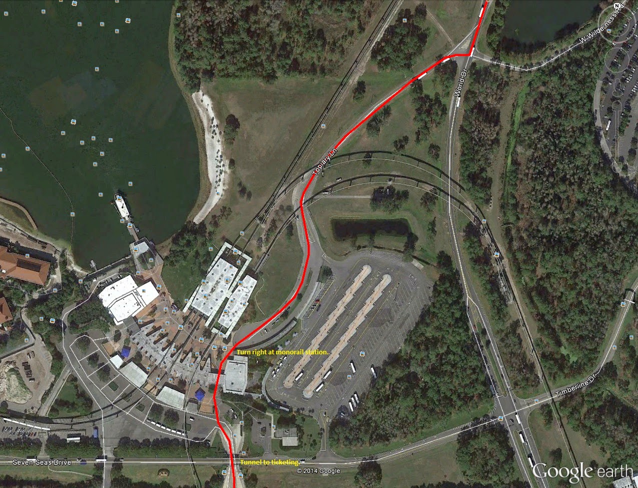
3.85mi-4.25mi: The section between the tram tunnel entrance to the monorail station,
the stretch of road past the bus park, and the intersection running back on to World Drive.
Along the Northern trek on World Drive, things become less uneventful as previous. First, runners are hoofing it along the Eastern edge of the Seven Seas Lagoon, a pretty backdrop in its own right. Ahead the massive Disney Contemporary Resort lay on the horizon. This stretch is the final bit before reaching park gates.

4.25mi: Back north along World Drive, with Disney's Contemporary Resort on the horizon.
4.5mi: The water bridge under the Seven Seas Lagoon. Yes, UNDER the lagoon.
Magic Kingdom, 5.0- The final bits of World Drive come at right near mile marker 5. From here, runners will turn left in to a employee/maintenance entrance towards the park.

4.95mi: The left-turn off World Drive (red line), with Space Mountain dominating the horizon ahead.
Then, a quick quarter-mile along a maintenance lot. At roughly 5.30 miles, finally, you come to a side entrance on to Main Street, USA of the Magic Kingdom.

5.00-5.35mi+: The short stretch of road from World Drive to Main Street, USA. The disc-like structure in the
upper right-hand corner is Space Mountain. The one in the center is the Carousel of Progress.
5.20mi: Runners will enter the park through a side entrance at the popular Confectionery
store front at the mouth of Main Street, USA in the Magic Kingdom. (photo credit: Scott Hanko)
5.25 miles or so is when you jump on to Main Street, USA, and the first steps on actual Disney park. Runners run straight North on Main Street, USA towards the Walt Disney statue that marks the crossroads of the park.

5.25mi: The view straight down Main Street, USA towards Cindarella's Castle.
At the Disney statue, barely a tenth of a mile later, runners take a right in to the aptly-themed Tomorrowland section of the park.

5.35mi: The aforementioned Disney statue. Take a
right-hander BEFORE this, heading in to...

...Tomorrowland! (photo credit: Scott Hanko)
From here, it's a run through the Eastern and Northeastern sections of the park, first with, of course, Tomorrowland, then Fantasyland, including a bit of the former (or is it still??) Toon Town.

In Tomorrowland, participants run past the Monster's, Inc. Laugh Factory before taking a left short of the central pavilion (the one with AstroOrbiter on its rooftop). From there, head along the stretch of walkway past the Tomorrowland Speedway. This runs you in to the Eastern-most section of Fantasyland, marked by the Mad Tea Party ride straight ahead. This section, from the opening of Tomorrowland to the opening of Fantsyland makes up about only 0.15mi, from 5.30 to 5.55 miles in to the race.

5.30-5.55mi: The trek through Fantasyland.
Within Fantasyland, take a right going around the back side of the Mad Tea Party, with the newly-built Cars-themed coaster on your right. This runs you in to Fantasyland's merry-go-round. Again, keep to your left and head straight towards Cindarella's castle. This section of Fantasyland, again is short -- not even two-tenths of a mile -- and runs you up to mile 5.75.

5.55-5.75mi: The run through Fantasyland.
5.70mi: The Fantasyland merry-go-round straight ahead. Stay to your left and you'll head back South though the castle.
Finally, at 5.75mi, runners get to hoof it through the famed Cinderella's Castle, the dominant centerpiece for the Magic Kingdom. The run-in will be from the North end of the castle, which is really the back side heading back towards the park entrance. Like before, head towards the Disney statue and take a right just before it, heading in to Adventureland.

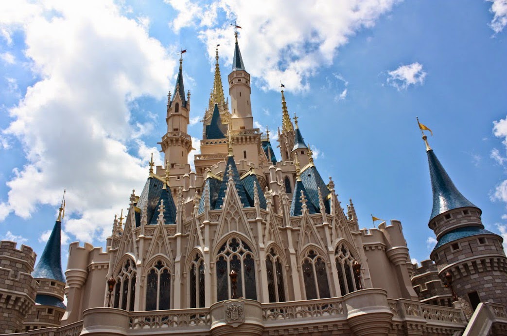
5.75mi: Look up! The view of Cindarella's Castle from its rear entrance (North side). (photo credit: Robert Lam)
The stretch of walkway from the Disney statue through to the Western-most edge of Adventureland makes up the final quarter-mile of the Magic Kingdom experience for runners, from miles 5.75 through to 6.10. Mile marker 6 comes right within Liberty Square.

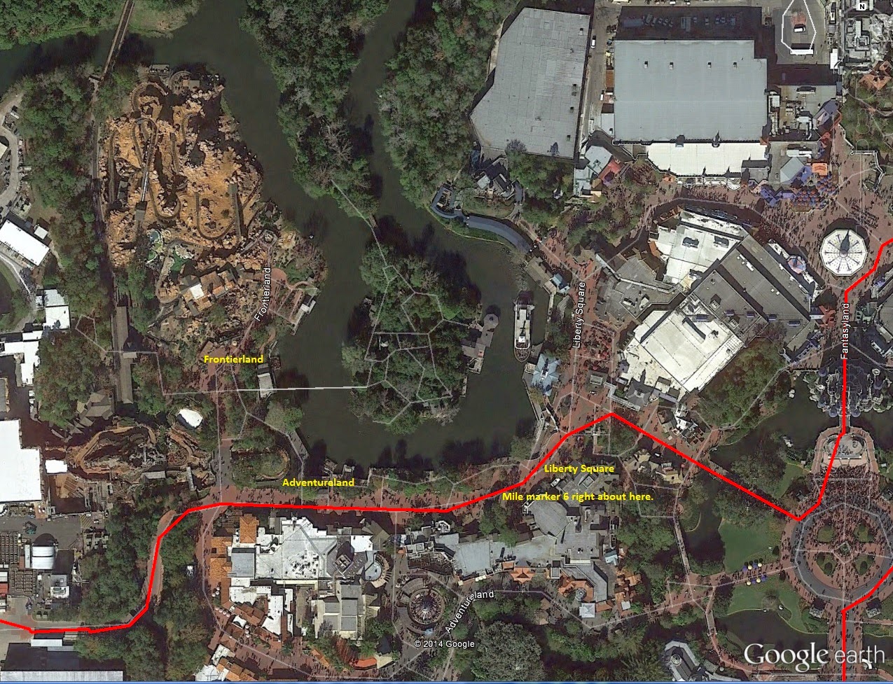
5.75-6.10mi: The course as it runs through Liberty Square, mile marker 6, and Adventureland.
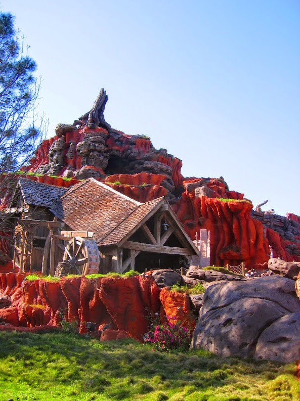
6.05mi: Just past mile marker 6, runners pass by the
Southern edge of Frontierland, including the ever-popular
Splash Mountain.
6.0-7.0mi: The route exits out a maintenance entrance along the Western edge of the park, right next to Splash Mountain (as a matter of fact both the runner's entrance and exit from the park are where the many Magic Kingdom parades also enter and exit). Pass by the many maintenance and storage buildings against the West side of the park on Caribbean Way, and back on to regular Floridian roads. Don't worry! This boring stretch doesn't last long.

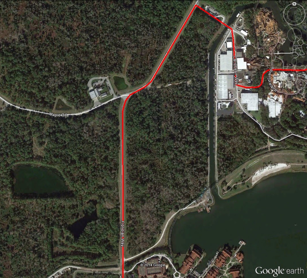
6.0-7.0mi: Mile marker 7 comes at just near the end of this Stretch of road, on Floridian Way.
6.35mi: Out of Magic Kingdom's storage area along the Western edge of the park (left side of image), and on to
Floridian Way South-bound (right side of image).
7.0-8.0mi: This stretch of road along Floridian Way becomes a little more exciting, as the route runs just to the West of the massive Grand Floridian Resort. However, most of this road is lined by trees on both sides, so many of the beautiful views from the road are obstructed. Disney execs reeeeally don't want you to enjoy the scenery unless you are guests of the hotel.

7.0mi: About where mile marker 7 would be. Just beyond the trees on the right, you can just see a bit of the Grand Floridan.
8.00-9.00mi: Now in this bit of course, there seems to be some confusion as to what is the correct route. All of the past half-marathons recorded (by the GPS watches of participants, i.e.) give it one way, yet the "official" course maps on the runDisney website have it another way. I'll give you both. Regardless of which is correct, the conditions are the same: flat. The only real difference is that the past-reported route runs to the south of the Richard Petty Driving Experience track, and the future-planned route (reported by runDisney) runs back through the parking lot and to the North of the track (basically, past mile 8, the same way out the way you came in). Additionally, near the end of this section of road -- about mile marker 9 -- is where full-marathoners break away from the half-marthoners. 

8.0-9.0mi: Excuse my freehand (blue and green). The route in red represents the most oft-reported half-marathon
route by past participants. The blue represents the planned half-marathon route (at least, planned for 2014) as reported
by the runDisney website. The green is also via runDisney, but represents the full marathon route.
9.0mi: If the race route posted on the runDisney site is correct, half-marathoners continue straight back through
the entrance (red line), and full-marathoners take the right-hand exit pictured.
9.0-12.0: Remember that boring highway you ran at the beginning of the race? It's time to do it again. Past the Magic Kingdom parking booths -- and mile marker 9 just beyond it -- it's the same stretch of World Way, this time Southbound back towards Epcot. Again, nothing really remarkable, until the exit back on to Epcot Center Drive, which, again, gives really the only incline seen on-route.

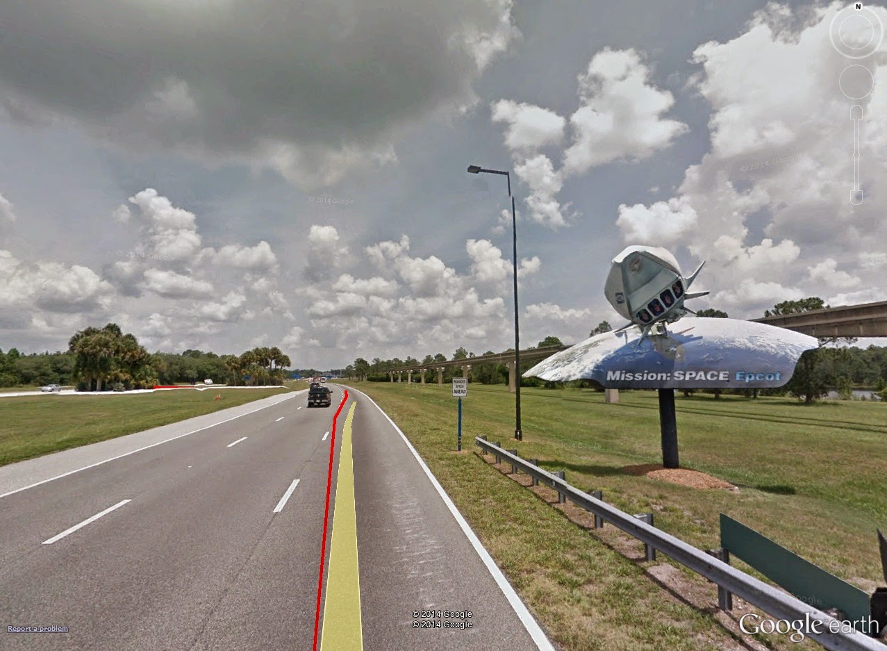
10.0mi: About where mile marker 10 would be is the bridge exit back on to Epcot Center Drive.
10.2mi: Stay to the right to exit back on to Epcot Center Drive. What little incline you see here -- that's pretty much it.
The run-in would seem the same as run-out, but luckily, for the final miles, it isn't. A quick switch-back on Epcot Center Drive puts runners in to Epcot's main lot, headed straight on in to the park. Surprisingly, from this switchback, and along the Western edge of the main lots, is nearly a mile long and more before reaching the first stretches of park.

10.5mi: A quick switch-back on Epcot Center Drive. This will take you in to the Western-most portion of Epcot's main lots.

Epcot Center, 12.0mi to Finish: Mile 12 comes just as runners are exiting the car park and in to the park's main bus drop-off area.

10.4-13.1mi: The final bits of route, through Epcot park. Runners enter on to the park grounds via the Southwestern-most
corner of the car park, and then along the Eastern-most edge of the bus drop-off area.
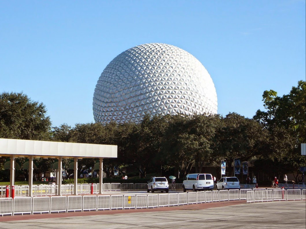
12.0mi: About the location of mile marker 12, at the Eastern-most edge of the bus drop-off area, after just exiting the
car park. The central attraction, Spaceship Earth, is clearly visible from here.


Wednesday, November 5, 2014

[BLOG UPDATE] I have MOVED...

Okay, so it was a bit ahead of "schedule," but I will not longer be updating this blog. All of my previous stuffs will remain, but nothing new will be added.

All of my old stuff, AND my new posts will now be at kcrunnersresource.weebly.com (soon to just be www.kcrunnersresource.com -- after the transition, typing in the old Weebly web address will automatically redirect you to the new domain).

So that's that! Check out my new site, which includes blog 'n all. And, of course, keep R/B/S'ing.

-t


Tuesday, October 21, 2014

[COURSE PREVIEW] Cliff Hanger 8k

2014 Cliff Hanger 8k -- Sunday, November 2nd, 9:00am
A 5k option is also offered, and begins at 8:00am

This event's official webpage can be found HERE.

Another autumn run race means another gorgeous route. One of the prettiest (I believe) is the Cliff Hanger 8k & 5k, a 5-ish-mile (unless you're a 5k-er) trek along Cliff Drive north of downtown Kansas City. Let there be no doubt: this one is worth doing for the scenery alone. However, on this course preview, you won't notice too many on-course (Virtual Run) photos -- most all of the route is...well...Cliff Drive. If you've been there before, you know what I mean. If not, you'll soon see for yourself.

Packet Pick-Up
For this race, packet pick-up IS ALLOWED on race day, although, like most races, organizers encourage packet pick-up beforehand (this opens up the volunteers to focus on more race-day-oriented tasks). Ahead of race day, there is one packet pick-up time, on Saturday (November 1st) from 12:00pm (noon) to 5:00pm at Gary Gribble's Running Sports in the Ward Parkway Mall. Like always, packet pick-up is always busiest at the start and end of the times offered, so plan accordingly if you're expecting a quick-in-quick-out.
Race-Day Parking
Given the location of the race itself, parking is a bit sketchy. Much of the parking is done along the roadways in the surrounding area, although there are two lots that are offered up for participant/spectator parking. The Kansas City University of Medicine and Biosciences is a sponsor of this event, and just so happens to live next door to the start line. On race day, a couple of their lots are the two mentioned previous, right off Highland Avenue. But do note: they are small. So early arrival is recommended.
Course Preview (with Virtual Run)
          Intro
If you are familiar with the 2013 route, I would assume nothing has changed. The event's website never posts the race route maps for either the 5k or 8k, so I'm left relying on my GPS information from last year. However, it's fairly straight-forward: 4k down Cliff Drive, turn around, 4k back. So really, it's only the start/finish line that would presumably change.

          Route Basics/Metrics
Picture
The 2013, and presumably, 2014 race route. The only real climb is highlighted on the course profile. However, it should be noted that a lot of these elevation changes could be affected by the surrounding trees (much of the course is covered by trees). (Image credit: Google Earth)
Here are the basics for the 2014 route...
  • Distance: 4.99mi
  • Route Type: Out-and-Back
  • Terrain Type: City, Park Roads (blacktop)
  • Start/Finish Location: Cliff Drive @ Lexington Avenue, Kansas City, Missouri
  • Start Elevation: 895ft
  • # Climbs: 1
  • Tot. Elevation Gain: 365ft
  • Official Map: -not given-

         Climbs
Only one climb on-route here. Here's what that one looks like...
  • River Market Finish: 0.27mi (2.84-3.11mi) @ 5.0% average grade (9.0% maximum), +42.6ft (757-798ft), 1/10 rating

         Virtual Run (all image credited to Google Earth Street View)
Cliff Drive is actually The Paseo past Lexington Avenue (just north of Hwy-24/Independence Avenue). At the intersection of The Paseo and Lexington, gates mark the start of Cliff Drive. The Start/Finish line is right beyond these gates.
Picture
0.00mi: The start of Cliff Drive. The start/finish line is just beyond the gateway (about where that red line starts).
Not even a quarter-mile in to the race, the road will seemingly split. To the right lay Lookout Point Drive, a gorgeous yet quick drive up the side of the cliff back towards Lexington. For the race, the route will stay left, dropping a bit on to the lower Cliff Drive.
Picture
0.25mi: The split in the road, with Cliff Drive on the left, and Scenic Lookout Drive on the right. Stay left. It drops quite a bit here, as well.
After about an additional quarter-mile drop (steep in spots, shallow in others), you land on to Cliff Drive. The lure of Cliff Drive comes due to its scenic overlooks to the right, looking over the river and in to North Kansas City, and its large limestone wall cliffs to the right. This time of year, beautiful fall foliage also covers the route directly overhead. Along with it being a closed course for this event, you couldn't ask for a better run.
Picture
0.65mi: The first of many sharp turns on-route. Nothing that'll slow you down, though. You can see one of those limestone cliffs on the right side of the image. Looking left would give you a beautiful view of North KC.
There is one opening that comes about a mile in (or a mile from the finish). Just to the South of Cliff Drive there is a small lake. This opening offers some side-of-the-road parking for the trail that runs around the lake. No, runners don't get to run around the lake.
Picture
1.00mi: A brief opening in the landscape for lake parking. The lake (or really, the pond) is ahead and on the right (not visible in this image). Consequently, this is about where mile marker 1 hits.
Beyond the opening, scenery returns to normal.
Picture
2.00mi: About where mile marker 2 would be, but it's not really helpful...this is about what every mile looks like on-route.
Really, a 5-mile(-ish) run is the perfect distance for Cliff Drive, as nearing the end of Cliff Drive is about 2.5 miles. At the race route turn-around, the exit gate is clearly visible ahead only 250 meters or so.
Picture
2.45mi: About the location of the turn-around for the 8k. You can see Cliff Drive's other gate up ahead.
The, back to business-as-usual for 2.5 miles. If you're aim is competition for this one, you may reach a point where your psyche starts to mess with you, as everything looks the same (no matter how gorgeous it may be). For me, last year, I kept looking for that opening at 1 mile that told me it was 1 mile to go -- and it felt like forever for me to reach it. Eventually, you hit it, followed quickly by the only significant climb on-route, with about a half of a mile to go.
Picture
4.70mi: The final meters of the only climb on-route. Though the average grade is "only" 2.7%, the maximum grades come in the second half of the climb, nearing 7- and 8% (like here).
Once you reach the top of the climb, you'll notice the "split" in the road from the beginning of the race -- where Scenic Overlook Drive comes back in to contact with Cliff Drive. At this point, it's only a quarter-mile to go! Nearing the finish, you'll likely notice the finish line banner rather than the Cliff Drive gates. Congrats on your finish!

          Strategy
In my humble opinion, runners versed in the 5k can get away with a 4-mile run -- just barely. It seems to me that right at 5 miles (for an 8k) is when a little extra training is needed if you intend to run competitively. One of my favorite training runs for 5k's is perfect tor training for an 8k: 1 mile warm-up, followed by 3x1-mile intervals at 5k-or-above effort, with a half-mile rest/jog between (So 1mi+1mi+.5mi+1mi+.5mi+1mi = 5mi). That, and of course, it's probably a good idea to test out an all-out 5mi effort. If you've trained for a recent 10k, you should be good to go.

On-route, competitive runners will be nearly flat-out the whole way. With a relatively flat course, the opening down-hill half-mile acts as a nice spring-board in to race-pace. Just watch out for that final climb! With only a quarter-mile to go, if you're battling with others, this is the perfect place to attack -- and attacks will only be successful for the adequately-trained.


Race report to follow.

Keep R/B/S-ing.

-tds
~~__o
  _-/<,_
@/   @

Friday, October 17, 2014

[BLOG UPDATE] HUGE News: This Site is MOVING...

I have outgrown the resources made available through a blog-only webpage. I must move on!

I will continue to update my Blogger page through the rest of the 2014 calendar year (including my Walt Disney World Marathon Weekend Coverage). However, as of January 1st, 2015, I will no longer be posting to my tylerdstaples.blogspot.com page.

I am currently transition all of my web content to a new webpage, and I am changing the name -- hopefully for the last time. KC Multisport Life will be called The Kansas City Runner's Resource, and is hosted by Weebly. The site is already available at kcrunnersresource.weebly.com.

As I said, I am currently in transition from this blog to my new site at kcrunnersresource.weebly.com. In my transition, I have decided to migrate over all of my pages and posts. This process is going to take a long time. Many of my first posts have been migrated, but there is still plenty of work to do.

Until my targeted January 1st date, I will post new course previews and race reports both on here (Blogger) as well as on the new KC Runner's Resource page.

In addition to my Blogger going kaput, once my Weebly site goes "live," I will have my own domain at www.kcrunnersresource.com. If you type in kcrunnersresource.weebly.com, it will automatically direct you to the domain.

So here's my the Clifsnotes...

  • October 16th: kcrunnersresource.weebly.com goes live,
    • Migration of Blogger site pages and posts begins.
    • Old posts on Weebly site that are not migrated yet will still link to Blogger post.
      • (aka all Weebly links are already active, but some link to Blogger instead)
    • New posts continue on both Blogger site and Weebly site.
  • October 31st: Blogger posts and pages are finished migrating to new Weebly site.
    • New posts continue on both Blogger site and Weebly site.
  • December 31st: New posts discontinue on Blogger site.
    • Blogger site will remain, but will no longer be updated.
  • January 1st: kcrunnersresource.weebly.com becomes kcrunnersresource.com
I think the move will improve website organization, as well as retain a section specifically for blogging (you'll see what I mean when you visit the new page). I also like the look and customization just a touch better.

If you have any questions/concerns/feedback, you know where to reach me.

Keep R/B/S-ing!!!

-tds
~~__o
  _-/<,_
@/   @

Thursday, October 16, 2014

[RACE REPORT] Kansas City (Half-) Marathon, Pt.II: Expo & Packet Pick-Up

Home Race Schedules & Reports > 2014 Kansas City (Half-) Marathon, Pt.II: Expo & Packet Pick-Up

This post is part two in a three-part series on the 2014 Kansas City Half Marathon. Part two covers the event expo, including packet pick-up. Other posts in this series include...
  • Part I (Course Preview w. Virtual Run): HERE
  • Part III (Race Day): [to be posted week of 10/20]
The event's official site can be found HERE.

Expo & Packet Pick-Up (to be updated afternoon of 10/16)
Packet pick-up is required pre-race (aka NO race-day packet pick-up). Packet pick-up, same as last year, is located at the event expo, at the Sheraton Kansas City at Crown Center, 2323 McGee Street (Exhibit Hall A). The following are the available pick-up times...
  • Thursday, October 16th, 3-8pm
  • Friday, October 17th, 11am-8pm
From the garage's ground level, these
little green arrows light the way.
For those that have been to the expo for Hospital Hill, this is the same location and Exhibit Hall (but bigger expo!). You can park at the Crown Center lots, but you'll incur the garage's $5 wrath. Though spots are few and far between at the Sheraton's lot, stalking expo goers for a spot is worth the $5 saved (which is $5 earned!). Just be sure to get your parking stamp validated at the expo (more on that in a second).

Once parked, take the elevators or stairs to the ground level. Once there, little green arrows will show the way to the Exhibit Hall. Just follow the green arrows!

Look at these helpful receipt-printing
volunteers!
In the week prior to expo time, event organizers sent out emails with confirmation emails of participants' registration. This email is needed for your actual packet pick-up. If you didn't print it off, fret-not! Just outside the exhibit hall is a row of tables with really awesome volunteers to help ease your confirmation-less woes! Just give them your name, and they'll print off a receipt with your confirmation information.

Now that that jazz is taken care of, get your parking validated! Right at the opening of the exhibit hall, there's a table specifically for validation. Just give them the parking ticket from Sheraton's garage, and a quick stamp will save you your $5. For 2013 athletes, this table is in pretty much the same location as last year.

Now to take care of the last bits of business, grab your packet! These are located at the very back of the exhibit hall. Presumably, this is so you're required to hit the exhibitor tables no matter what, but I like to wait for that table stroll until after my packet is in-hand. Like last year, these are organized by bib number, NOT by last name (hence the required confirmation email).
The relay tables were nearly empty. Half-marathon? Not so much.

If you're a late registerer, you're all the way to the right. Next from right are the kiddy runners, relayers (black signs), then half-marathoners (green signs), and finally full marathoners nearly all the way to the left of the back wall (blue signs). Upon my arrival, nearly right at 3pm on the first expo day, the half-marathon tables were packed. This is always going to be hit-or-miss, but usually the busiest times for packet pick-up are right at the start, right at the end, or during natural breaks in the day (such as around the lunch our, or at rush hour time). Plan accordingly

Now you can hit the actual expo part of the expo! Various vendors showcase at the expo -- about the same as Hospital Hill (this year at HH, I picked up a Fitletic number holder on the cheap). UltraMax Sports, the Running Well Store, and KC Running Company store are just a few of the local vendors. Take your time, and appreciate the work of all the exhibitors that took their time to come on out!

I believe that's about it. You got your packet, your goodies, go home and start carb-ing up!!

Until then, keep R/B/S-ing.

-tds
~~__o
  _-/<,_
@/   @

Wednesday, October 15, 2014

[RACE REPORT] An unlikely PR: The Mustache Dash 5k

Home Race Schedules & Reports > 2014 The Mustache Dash 5k

The event's official site can be found HERE.

The resulting race day goodies.
Local runners may be familiar with this one; perhaps one of the more popular themed races is the Mustache Dash 5k. This year there are five offerings throughout the midwest, including Omaha, St. Louis, Wichita, Tulsa (OK), and Leawood (KS). This one will, of course, be covering the KC-area version, Leawood.

Pre Race
          Course Preview
Link to this route in Google Maps can be found HERE.
For my in-depth course preview write-up, visit the course preview post HERE.

The 2014 route, with Roe climb noted (image courtesy of Google Earth).

          Battling both kinds of cold.
My time spent at the packet pick-up (this year located at KC Running Company's new retail store -- which is awesome, by the way) was short-lived and sans-pictures. This year, three days out, I came under the spell of a nasty sinus infection. By Friday, my race plans were tentative, as any prolonged time spent vertical left my sinuses throbbing and my head spinning. Certainly running in this condition was next to physically impossible. The final days of the week presented with dreary and cold conditions as well -- which wasn't helping.

Jump to Friday morning, 6:30am, and I woke up surprisingly clear. No, I wasn't anywhere near 100%, but I could stand. Therefore, I would run. The only concern at this point: barely-40-degree morning weather might put me back under the...well...weather. And only one week until KC Marathon race day? Yikes.

First, our Nation's anthem. That chick next to me
looked way more serious than I (better mustache, too)
(photo credit: KC Running Company)
I jacket-ed up, and nearly succumbed to tights as well (I didn't). Arriving on-site, I could tell the initial adrenaline of waking on race morning was wearing off. Out in the cold, my sinuses (and lungs) were started to argue with me once more. My head swimming, I barely got in a warm-up run, misplacing the correct start time by about 30 minutes. I got in as many strides as I could before it was time to line up. This wasn't going to be pretty...

Race Day

The start line was still cold, even after a warm-up. Some of that could still have been the infection running through my veins, though. Five minutes from start, I had no idea what to expect out of my legs, and my body. I'd been on nearly four complete days of rest, sick during all, and not a solid mile run in nearly a week (I had planned for a long run the day I came down with the illness).

And, they're off! (photo credit: KC Running Company)
The pre-race time expired, and all were off. Within the first 300m, a natural group of five formed. I didn't quite have the speed, so I held off from attempting to stick. By 500m, the group shed two more runners, with myself remaining in sixth (P6). Seventh and eighth were gaining a touch, but I was able to hold well through the first mile marker.

As my watched beeped one mile, I could feel my lungs start to sting from the cold, and the cold (redundancy intended). I ignored my watch -- I didn't want to see how poorly I was running, although I was happy with retaining a top-10 spot. Surely I couldn't keep it for long, with my lungs starting to argue with me (but, surprisingly, my legs holding firm).

North on Nall, P6 at this point
(photo credit: KC Running Company)
Beyond mile marker 1, the road began to pick up. Ascents adorned the first mile, too, but nothing that registered with my legs. Ascending toward College Boulevard, my legs still held, by my lungs turned from sting to sear. But still, I pushed, following the turnover of my legs as much as possible.

Turning off of College and to Roe, there was another uptick towards the 2-mile marker. I could hear
the steps of P7 and P8 edging up behind me. Oh the uptick, I was able to hold, followed by a long descent. Here, both 7th and 8th passed, pushing me in to P8. My legs were finally fatiguing, and the quad-pounding of the down-slopes proved painful. Then, the only significant climb on-route hit on approach back towards Town Center. With the brief break for my breathing, I was able to give a slight surge.

Turning on to 117th towards Town Center, I looked back towards the corner -- 9th was a ways back, but if I let up too much I could risk my 8th place finish. Up ahead, I was able to match pace with P6 and P7, but not gain any ground. P5 was losing ground to 6th and 7th, but not enough that I could overtake. Approaching mile 3, the name of the game would be maintenance.

The finish, at a PR 20:16, and in a solid 8th.
(photo credit: KC Running Company)
In through the Park Place parking garage, I did a double-check behind me. I had a good 15-second lead over 9th. Final corner and on to the final stretch, I let up a touch. Then, looking towards the finish line, I saw what I had yet to see ever: 19:50. A sub-20 time!???? For me, over the last year, that was the holy grail. With nearly a tenth of a mile to go, there's no way I could cover 10 seconds or less. But suddenly the sub-20 seemed within reach. Ignoring my watch the whole race, I had no idea how close I was. I started to ask: did ignoring my watch help my time? Or would seeing my watch and how close to sub-20 I was given me the extra push to actually grab sub-20? Hard to tell, but one thing was fore sure...I had to surge now -- a PR was no on the line. I kicked -- hard -- and crossed at 20:16.

Sub-6:30 for the first time ever. The long-awaited PR. I had been aiming for this for seven months now. I had ticked sub-6:30 finally. Now the only next stop was sub-20. Then, who knows. Sub-6:00?? The coveted 5:30??? A door I had been knocking at all year finally chose to creak open. All whilst batting the cold and a cold. Who would've thought??

Race Metrics

  • Distance: 3.15mi
  • Time: 20:16
  • Avg. Pace (Max. 1mi Split): 6:26 (6:08)
  • HR Avg. (Max.): 176bpm (191bpm)
  • Calories: 356kcal
  • Elev. Gain: +167ft
  • Avg. Cadence (Max.): 178spm (190spm)
  • Avg. Vertical Oscillation: 9.8cm
  • Avg. Ground Contact Time: 223ms
  • Avg. Stride Length: 1.40m
  • Garmin Connect Activity Page: HERE


Keep R/B/S-ing.

-tds
~~__o
  _-/<,_
@/   @